
March 05, 2009
Angrypig experimented with chromium code and ultimately managed to integrate the browser into our engine. Works fairly well, with mouse and keyboard too. It's still just a prototype, though; the integration with the engine will be reworked and optimized for example to have to update only the change…
February 25, 2009

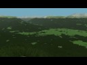
When I tried to visualize resolution of elevation dataset we are currently using, it occurred to me it would be a good idea to visualize also the various steps and enhancements to the procedural refinement algorithm. These more or less show also how the algorithm evolved.
First, the terrain rendered…
First, the terrain rendered…
January 29, 2009

Playing with detail texturing.
First creating detail material map for each tile, computed from terrain data - elevation, slope and curvature, using two additional fractal channels for mixing.
The algorithm first computes slope, if it's steeper than some defined angle of repose it's considered to be a…
First creating detail material map for each tile, computed from terrain data - elevation, slope and curvature, using two additional fractal channels for mixing.
The algorithm first computes slope, if it's steeper than some defined angle of repose it's considered to be a…
December 02, 2008

We tried Vimeo's HD videos and the result is here, with music giving it somewhat different mood [oh]
Only afterwards I noticed that the function computing the tree distribution stopped working correctly after some variables (namely the local terrain curvature) changed in magnitude as they are comput…
Only afterwards I noticed that the function computing the tree distribution stopped working correctly after some variables (namely the local terrain curvature) changed in magnitude as they are comput…
November 21, 2008
Managed to finish some other tasks before the shadows and detail ground textures.
First was placing objects on terrain, with persistence to cache. Later the local cache will be synced with a server, which will be also used to retrieve objects existing anywhere in the world, placed there by other use…
First was placing objects on terrain, with persistence to cache. Later the local cache will be synced with a server, which will be also used to retrieve objects existing anywhere in the world, placed there by other use…
November 06, 2008

I am now reading the generated terrain tile data back from GPU and doing basic collision testing (ray vs. terrain). We test it with one model of man we call ">Jose Jalapeno, because of the lacking animation. [smile]
The yellow lines that are visible somewhere mark the boundaries of the tile wher…
The yellow lines that are visible somewhere mark the boundaries of the tile wher…
October 19, 2008

We created XnView plugin for viewing terrain elevation maps (raw or srtm files) to help us visualize input heightfield data in any combination of format (8-, 16- or 32-bit depth, signed or unsigned, integer or floating point, endianness etc.).
The plugin also autodetects image dimensions by computin…
The plugin also autodetects image dimensions by computin…
August 29, 2008

In addition to the elevations that are read from wavelet-compressed dataset and then refined by fractal algorithm, the engine computes 3 other fractal channels in parallel. These contain 'normal' fractals that will be used as source for coherent random values for various engine parts.
First of these…
First of these…
August 21, 2008

August 02, 2008

We've added some simple, crude billboard trees into the terrain. These are generated in fragment shader after the tile elevation map is computed. There can be one tree in roughly each 2x2 meter square; whether there actually is one is determined by an ecotype probability equation that takes into ac…
July 30, 2008

Hi everybody.
I'd like to introduce our project - a planetary engine.
Features:
I'd like to introduce our project - a planetary engine.
Features:
- Planetary engine that can be used with an elevation dataset, enhancing its resolution using fractal algorithms. Resolution of the elevation data is arbitrary, fractal algorithms further refine the detail down to under-foot…
Advertisement
Popular Blogs


Advertisement