Lately I've been working on building up a game's terrain from grid-aligned pieces. We might call these pieces metatiles because each piece is made of a collection of grid tiles that work together to create a unified feature in the game world. The beauty of this approach is that it fits neatly within the grid of a height mapped terrain. The difficulty is determining how to maximize the flexibility of the system using very few metatiles. Not only does a metatile require time and effort to design and model, but having a vast library of metatiles to choose from would complicate the world editing process.
In my experience, most complicated metatiles boil down to arrangements of a few fundamental types of pieces. My idea is to simplify the whole process by restricting the game to features built up out of these six metatiles, plus flips and rotations:
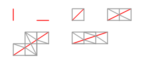
The red lines represent the feature that is drawn through the grid cells, and the gray lines represent how the cell is triangulated around the feature. For example, the red line might represent a vertical cliff or the boundary between one area and another, like the edge of a road or the shore of some body of water.
These pieces, plus the flexibility of a height map, should be enough to create a wide variety of game terrains. The question is how does one build build an easy-to-use editor around assembling such small metatiles? For example, you can build up a curve out of these pieces by starting at a point and dragging the mouse in the desired direction. The editor would automatically choose the piece that most closely matches the direction from the current point to the mouse cursor. We can preview the next piece and perhaps wait for a mouse click to accept it, then continue with yet another piece until the curve catches up with the mouse. If the next piece would overlap with an existing piece, we display the preview in an error color and refuse to place the piece.
Has anyone ever seen a system like that?
While the above seems technically sufficient, there are a few details that would make editing awkward without additional automation. For example, a road would usually tend to have two parallel edges, and manually creating two parallel edges along a curved road in a system like this would be tedious and tricky. There is also a question of UV-mapping and how the user would specify the UV-coordinates of things like cliff walls and road surfaces. Ideally UV-coordinates would be handled entirely automatically.